Back in Angela's Arms .................August 23rd
The gadgies have been quiet for a couple of weeks after the great Fort William and Orkney adventures. Two weeks ago I went to watch England play Australia in the fourth test match at Chester le Street. A great game, England won on the fourth day. I feel sorry for non cricketing nations. Last Friday I had family commitments, as have several gadgies today so we are reduced to a turn out of four and have opted for a fairly local walk from Alnham. We are, John, Brian, Dave and me.
This walk has been described twice before:
Alnham, Gateway to the North January 13th 2012 and
Ancient and Modern February 2nd 2012
Alnham is a backwater in rural Northumberland, a few houses and farms close to the River Aln, surprisingly. But it has a long history; there is an Iron Age fort (Castle Hill) whose bivallate site is clearly visible, St. Michaels Church, renovated in 1870 but dating back to 1200, and the site of a Medieval Castle mentioned as long ago as 1405 and probably destroyed by the Scots at some time. And there is evidence of several ancient settlements on the walk.
To get to Alnham from Newcastle follow the A1 north, the A687 from Morpeth and turn left at Whittingham, watching out carefully for signposts directing travellers to the hamlet. It is possible, and permissible, to park on the grass verge outside the church at GR. NT991109 on OS map OL16 The Cheviot Hills.
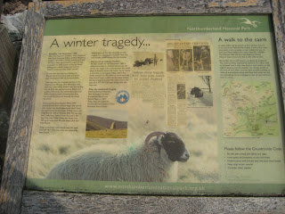 An information board outside the church relating the
sad tale of the shepherds who perished in the winter of 1962.
 St. Michael's Church, Alnham.
The walk, which is relatively gentle.
Walk past the church and Tower House, which was once a vicar's pele tower (Fortified house) and turn up the footpath on the right which crosses the mighty river Aln, very much in its infancy. Cross a small field, walk through the narrow plantation and cross a larger field labelled Northfieldhead on the OS map.
Take care; deep in conversation, no doubt something highly controversial or philosophical, John and I wandered on ahead of the others before we realised they had vanished. We retraced our steps a short way and took the signed path heading roughly north, staying on it all the way to Cobden and ignoring the path off to the left which is part of the Salter's Road. There is a memorial stone to poor Nellie Heron a lady who was caught in a storm one night in the 19th century and died, not too far from shelter. It is off the track and difficult to find although we found it once. We finally caught up with the others at Cobden and headed down to Alnhammoor Farm for lunch, distance covered so far 3.8 miles but without the sustenance usually provided by a bacon sandwich.
Alnhammoor is a pleasant enough Herbie Spot and the usual sandwiches were enhanced by Mrs. A's chocolate covered offering and Dave's Yorkshire super sweet flapjacks. I forgot the chocolate.
We saw a couple studying a book of walks and an OS map. They were from Pudsey so presumably liked cricket but were a little concerned about the directions given for their walk in the book. We sent them on the correct route. We should have advised them to read gadgie blogs for walks.
 The River Breamish at the Herbie Spot.
 Alnhammoor Farm.
Lunch over we continued on our way, walking past the farm and taking the footpath on the left which crosses a stream by means of a wooden footbridge and followed the footpath across the grouse moors above the Shank Burn until we came to a fairly new looking gravelled track, probably built for the shooting fraternity. Turning left we stayed on the track, crossed the Shank Burn and headed up to the gap in the plantation that leads to Ewartly Shank. (Ewart means an enclosure by a river, but I can't find a definition of Shank; all offerings welcome.)
 Typical Northumberland, with future trees!
 Road to the moors
 Trap for innocent creatures such as stoats who may
eat grouse eggs or fledglings.
There is a new map on the fence at Ewartly Shank showing the footpath round the farm, which is fair enough. However the map is upside down so be careful, some farmers, but not many in Northumberland, get upset if you leave a footpath.
From the farm the road leads all the way back to Alnham. It is possible to divert from the road to see the memorial stone to the shepherds who died in 1962, or to divert to see the remains of the Iron Age fort at Castle Hill.
Back at the car we changed and headed for the Anglers Arms at Weldon Bridge where we welcomed by the usual cheery staff. The beers of choice were Speckled Hen, Directors and Ruddles, the latter two being in excellent condition. They must have known we were coming, they had The Beatles Number 1s on! Of course we sang along.
 Angelas' Arms
A shortish walk but very enjoyable on a warm but cloudy day, especially after a lay off from the boots.
 Start and finish at Alnham church. Herbie Spot at Alnhammoor Farm
Matrix MMMVI
steps miles
ASDAPED 17817 8.37
LIDL3D 20045 9.02
Daves LIDL 3D 19036 8.75
LIDLUSB 18673 8.83
OUTDOORS GPS 8.80
Some consistency for once and the walk, including stops took 3 hours 30 minutes
Bird of the blog
Quiet day for birds, a kestrel was the best!

Kestrel ( or Windhover; a poem by Gerald Manley Hopkins)
A new free magazine is about to appear called OUTDOORS NORTH EAST. Currently available on line at www.outdoorsne.co.uk
The gadgies have been quiet for a couple of weeks after the great Fort William and Orkney adventures. Two weeks ago I went to watch England play Australia in the fourth test match at Chester le Street. A great game, England won on the fourth day. I feel sorry for non cricketing nations. Last Friday I had family commitments, as have several gadgies today so we are reduced to a turn out of four and have opted for a fairly local walk from Alnham. We are, John, Brian, Dave and me.
This walk has been described twice before:
Alnham, Gateway to the North January 13th 2012 and
Ancient and Modern February 2nd 2012
Alnham is a backwater in rural Northumberland, a few houses and farms close to the River Aln, surprisingly. But it has a long history; there is an Iron Age fort (Castle Hill) whose bivallate site is clearly visible, St. Michaels Church, renovated in 1870 but dating back to 1200, and the site of a Medieval Castle mentioned as long ago as 1405 and probably destroyed by the Scots at some time. And there is evidence of several ancient settlements on the walk.
To get to Alnham from Newcastle follow the A1 north, the A687 from Morpeth and turn left at Whittingham, watching out carefully for signposts directing travellers to the hamlet. It is possible, and permissible, to park on the grass verge outside the church at GR. NT991109 on OS map OL16 The Cheviot Hills.

sad tale of the shepherds who perished in the winter of 1962.

The walk, which is relatively gentle.
Walk past the church and Tower House, which was once a vicar's pele tower (Fortified house) and turn up the footpath on the right which crosses the mighty river Aln, very much in its infancy. Cross a small field, walk through the narrow plantation and cross a larger field labelled Northfieldhead on the OS map.
Take care; deep in conversation, no doubt something highly controversial or philosophical, John and I wandered on ahead of the others before we realised they had vanished. We retraced our steps a short way and took the signed path heading roughly north, staying on it all the way to Cobden and ignoring the path off to the left which is part of the Salter's Road. There is a memorial stone to poor Nellie Heron a lady who was caught in a storm one night in the 19th century and died, not too far from shelter. It is off the track and difficult to find although we found it once. We finally caught up with the others at Cobden and headed down to Alnhammoor Farm for lunch, distance covered so far 3.8 miles but without the sustenance usually provided by a bacon sandwich.
Alnhammoor is a pleasant enough Herbie Spot and the usual sandwiches were enhanced by Mrs. A's chocolate covered offering and Dave's Yorkshire super sweet flapjacks. I forgot the chocolate.
We saw a couple studying a book of walks and an OS map. They were from Pudsey so presumably liked cricket but were a little concerned about the directions given for their walk in the book. We sent them on the correct route. We should have advised them to read gadgie blogs for walks.


Lunch over we continued on our way, walking past the farm and taking the footpath on the left which crosses a stream by means of a wooden footbridge and followed the footpath across the grouse moors above the Shank Burn until we came to a fairly new looking gravelled track, probably built for the shooting fraternity. Turning left we stayed on the track, crossed the Shank Burn and headed up to the gap in the plantation that leads to Ewartly Shank. (Ewart means an enclosure by a river, but I can't find a definition of Shank; all offerings welcome.)


eat grouse eggs or fledglings.
There is a new map on the fence at Ewartly Shank showing the footpath round the farm, which is fair enough. However the map is upside down so be careful, some farmers, but not many in Northumberland, get upset if you leave a footpath.
From the farm the road leads all the way back to Alnham. It is possible to divert from the road to see the memorial stone to the shepherds who died in 1962, or to divert to see the remains of the Iron Age fort at Castle Hill.
Back at the car we changed and headed for the Anglers Arms at Weldon Bridge where we welcomed by the usual cheery staff. The beers of choice were Speckled Hen, Directors and Ruddles, the latter two being in excellent condition. They must have known we were coming, they had The Beatles Number 1s on! Of course we sang along.

A shortish walk but very enjoyable on a warm but cloudy day, especially after a lay off from the boots.

Matrix MMMVI
steps miles
ASDAPED 17817 8.37
LIDL3D 20045 9.02
Daves LIDL 3D 19036 8.75
LIDLUSB 18673 8.83
OUTDOORS GPS 8.80
Some consistency for once and the walk, including stops took 3 hours 30 minutes
Bird of the blog
Quiet day for birds, a kestrel was the best!
Kestrel ( or Windhover; a poem by Gerald Manley Hopkins)
A new free magazine is about to appear called OUTDOORS NORTH EAST. Currently available on line at www.outdoorsne.co.uk
No comments:
Post a Comment