Le Gyle du Vent..... September 14th
This walk is very popular with the gadgies, particularly when we don't want to go far or we want to buy free range eggs. It is a shortened version of Across the Borderline February the 3rd and is the walk to Windy Gyle, which certainly lived up to its name today.
To get to the start, Barrowburn, take the A1 north, A697 at Morpeth, turn off left for Rothbury on the B6344 and go through Rothbury and Thropton, turning right at the signpost for Alwinton and Harbottle. Drive through both and keep going for several miles until you come to a small car park and picnic spot.on the left next to a rather dilapidated looking hall. Using map OL 16, "The Cheviot Hills", (and a map is useful on this walk) the car park is at GR866104.
There are five gadgies out today: route, pun, vogel, debonair and blogpiemeister, all squeezed in to a Ford Focus. We stopped for a late breakfast in Rothbury,* dining at Tomlinson's Cafe and Bunkhouse on Bridge Street.. An excellent establishment, friendly ambience, good menu and colouring books for children in the table drawers. Harry enjoyed those. The menu offered bacon baps** which we ordered. The waitress apologised and said they had no baps, but could offer wholemeal brown bread. A slight disappointment, bacon sandwiches should come in a bun at least, and for this reason what would have been a five flitch was reduced to a four. The bacon sandwich came with a tasty little side salad and a large pot of tea. Great cafe, to be recommended.
Jovial early morning chat produced some good puns but sadly they are not fit for a family publication.
The Walk,
Normally there is a set route for this walk but we decided for two reasons to reverse it and go in a clockwise direction because it seemed like a good idea at the time and we also thought that this would give us the wind on our backs on the tops, and it was windy.
 The car park at Barrowburn, not really interesting , but part of the walk. Barrow could mean briar and burn means stream.
Leaving the car park we turned left and followed the road past the phone box near Barrowburn farm, which has a nice little tea shop with home made cakes, and walked on tarmac for the best part of a mile before coming to a junction. The road follows the Rowhope Burn and eventually reaches the farm at Uswayford. Don't take it but instead choose the clearly visible path that leads uphill across fields. This path goes in a northwesterly direction and is marked on the map as The Street. It goes along the side of Swineside Law*** and crosses the Black Braes before reaching the border fence. There is a signpost to help you, pointing along the Pennine Way.The wind was very strong as we walked, making me pleased that my 13 stones (182 pounds) was quite difficult to blow over. Because of the wind we stopped near the border fence, in a hollow, and declared a Herbiespot for the consumption of the usual pies and sandwiches.
Refreshed we continued on our way along the border fence until we reached the cairn at Windy Gyle.
 Cairn and Trig Point at Windy Gyle.
After a short break, mainly to admire the views looking north into Scotland and south into England, east to the sea we set off again, possibly. The routemeister, who is a very good photographer, although I coyly admit some of my more serious efforts have even been praised by the wife, was busy taking landscapes. Debonair and punmeister walked off, Vogel and I left shortly afterwards, thinking routemeister Harry was right behind us. The footpath, which in places is paved with old flagstones from defunct cotton and wool mills follows the border fence, passing Russell's Cairn (See Across the Border Line) and the delightfully named Blair's Hole, several small piles of stones which are old border markers until it reaches a gate and signpost.
 Northumbrian Landscape. I have taken better.
Looking back Harry the routemeister was not to be seen, not even with the aid of binoculars. Nor could vogel and I see the punmeister or debonair. We waited a while before deciding the routemeister must have taken the shorter route from Windy Gyle There was another walker, doing the Pennine Way from north to south who offered to look out for the routemeister, so off we went, heading on a path which starts in a south easterly direction but soon turns almost due south.
 Another Northumbrian Landscape.
The path goes between coniferous plantations before reaching the road that goes left to Uswayford or right towards Rowhope. Cross the road and take the path across fields. On the left, in the valley is a wooden footbridge. I tell you this as a pointer, do not cross it, but keep on the path until it reaches a plantation. Continue through the wood, but at the first junction take the right hand path and continue through the plantation in a southerly direction until emerging into fields. From here the walk continues uphill on the side of Kyloe Shin before it descends again.
On the right hand side, across the valley is, clearly visible, a field bank, possibly 18th century, and alongside it a 19th century wall and between them a 20th century wire fence.
 Wall on the left, bank on the right.
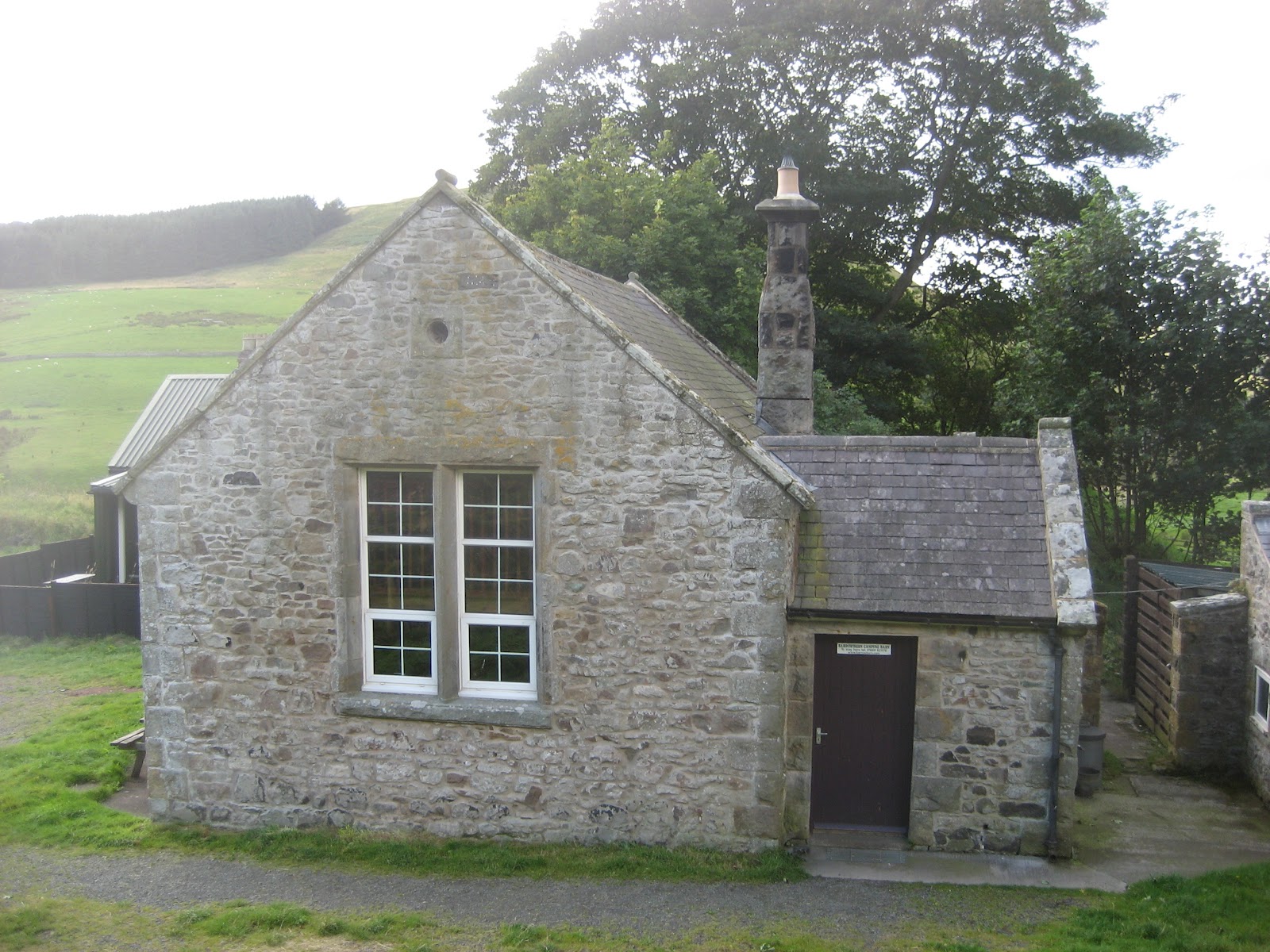
Close by is the old school and teacher's house, now used as a bunk house, The Deer Hut.
 The Deer Hut, formerly the village school.
The footpath leads past he hut, along a fence and then turns right to cross the stream at Wedderleap. (See Across the Borderline). A short way down the road to the car park and there was the routemeister who had, as we thought, taken a short cut.
Changed we headed for the Anglers' Arms at Weldon Bridge to refresh our throats. Ruddles County and Cumberland bitter were on offer, and very refreshing they were too. Five barrels again.

The Matrix steps miles
ASDACURVE 22210 10.52
USBLIDL 23944 11.33
HIGEAR 23677 10.75
And Outdoors GPS claimed 11.2 miles
* Rothbury; from "Hrotha's Berg" a fortification belonging to Hrotha
** Bap. A flattish bread bun, 16th century English but origin unknown
*** Law Old English |"hlaw" meaning hill.
This walk is very popular with the gadgies, particularly when we don't want to go far or we want to buy free range eggs. It is a shortened version of Across the Borderline February the 3rd and is the walk to Windy Gyle, which certainly lived up to its name today.
To get to the start, Barrowburn, take the A1 north, A697 at Morpeth, turn off left for Rothbury on the B6344 and go through Rothbury and Thropton, turning right at the signpost for Alwinton and Harbottle. Drive through both and keep going for several miles until you come to a small car park and picnic spot.on the left next to a rather dilapidated looking hall. Using map OL 16, "The Cheviot Hills", (and a map is useful on this walk) the car park is at GR866104.
There are five gadgies out today: route, pun, vogel, debonair and blogpiemeister, all squeezed in to a Ford Focus. We stopped for a late breakfast in Rothbury,* dining at Tomlinson's Cafe and Bunkhouse on Bridge Street.. An excellent establishment, friendly ambience, good menu and colouring books for children in the table drawers. Harry enjoyed those. The menu offered bacon baps** which we ordered. The waitress apologised and said they had no baps, but could offer wholemeal brown bread. A slight disappointment, bacon sandwiches should come in a bun at least, and for this reason what would have been a five flitch was reduced to a four. The bacon sandwich came with a tasty little side salad and a large pot of tea. Great cafe, to be recommended.
Jovial early morning chat produced some good puns but sadly they are not fit for a family publication.
The Walk,
Normally there is a set route for this walk but we decided for two reasons to reverse it and go in a clockwise direction because it seemed like a good idea at the time and we also thought that this would give us the wind on our backs on the tops, and it was windy.

Leaving the car park we turned left and followed the road past the phone box near Barrowburn farm, which has a nice little tea shop with home made cakes, and walked on tarmac for the best part of a mile before coming to a junction. The road follows the Rowhope Burn and eventually reaches the farm at Uswayford. Don't take it but instead choose the clearly visible path that leads uphill across fields. This path goes in a northwesterly direction and is marked on the map as The Street. It goes along the side of Swineside Law*** and crosses the Black Braes before reaching the border fence. There is a signpost to help you, pointing along the Pennine Way.The wind was very strong as we walked, making me pleased that my 13 stones (182 pounds) was quite difficult to blow over. Because of the wind we stopped near the border fence, in a hollow, and declared a Herbiespot for the consumption of the usual pies and sandwiches.
Refreshed we continued on our way along the border fence until we reached the cairn at Windy Gyle.

After a short break, mainly to admire the views looking north into Scotland and south into England, east to the sea we set off again, possibly. The routemeister, who is a very good photographer, although I coyly admit some of my more serious efforts have even been praised by the wife, was busy taking landscapes. Debonair and punmeister walked off, Vogel and I left shortly afterwards, thinking routemeister Harry was right behind us. The footpath, which in places is paved with old flagstones from defunct cotton and wool mills follows the border fence, passing Russell's Cairn (See Across the Border Line) and the delightfully named Blair's Hole, several small piles of stones which are old border markers until it reaches a gate and signpost.

Looking back Harry the routemeister was not to be seen, not even with the aid of binoculars. Nor could vogel and I see the punmeister or debonair. We waited a while before deciding the routemeister must have taken the shorter route from Windy Gyle There was another walker, doing the Pennine Way from north to south who offered to look out for the routemeister, so off we went, heading on a path which starts in a south easterly direction but soon turns almost due south.

The path goes between coniferous plantations before reaching the road that goes left to Uswayford or right towards Rowhope. Cross the road and take the path across fields. On the left, in the valley is a wooden footbridge. I tell you this as a pointer, do not cross it, but keep on the path until it reaches a plantation. Continue through the wood, but at the first junction take the right hand path and continue through the plantation in a southerly direction until emerging into fields. From here the walk continues uphill on the side of Kyloe Shin before it descends again.
On the right hand side, across the valley is, clearly visible, a field bank, possibly 18th century, and alongside it a 19th century wall and between them a 20th century wire fence.

Close by is the old school and teacher's house, now used as a bunk house, The Deer Hut.
The footpath leads past he hut, along a fence and then turns right to cross the stream at Wedderleap. (See Across the Borderline). A short way down the road to the car park and there was the routemeister who had, as we thought, taken a short cut.
Changed we headed for the Anglers' Arms at Weldon Bridge to refresh our throats. Ruddles County and Cumberland bitter were on offer, and very refreshing they were too. Five barrels again.

The Matrix steps miles
ASDACURVE 22210 10.52
USBLIDL 23944 11.33
HIGEAR 23677 10.75
And Outdoors GPS claimed 11.2 miles
* Rothbury; from "Hrotha's Berg" a fortification belonging to Hrotha
** Bap. A flattish bread bun, 16th century English but origin unknown
*** Law Old English |"hlaw" meaning hill.
What was the purpose of a field wall?
ReplyDeleteEither as a property line or as a wall. It would have been higher when it was built, sufficient to keep out animals but not marauding Scots
ReplyDelete