Days of Rhyme and Poesies..................August 3rd
(Not many torists out today)
I go walking with the gadgies,
We walk on hills and dales,
This year we went to Scotland,
Next year it might be Wales.
As I was about to leave the house, my wife (of 43 years and 1 day) said, with a hint of sarcasm,
"Look at you, your clothes are coordinated for once, grey trousers, grey T shirt and grey socks. Are you feeling OK?" How have we stayed together so long. Pure luck, I rarely care about these things.
There are four of us out today, the punmeister, the vogelmeister, the routemeister who has forgotten his map and me.
Today's walk is back on home territory in Northumberland, starting from Wooler and walking St. Cuthbert's Way to the Newton Tors. (And you thought it was a spelling mistake!)
To get to Wooler take the familiar A1, A697 and turn into the small country town.
We parked the car and headed for the main street to find a cafe for a bacon sandwich and tea. The establishment scored 3.5 flitches: the bacon was fine, the bun was better than usual, the tea was strong but a smile with the service would have been appreciated.
After breakfast we headed up Ramsey's Lane, almost directly opposite the Wheatsheaf Hotel, following the signpost for Wooler Common. There is, after about a mile, a car park with an information board.
A map is advisable, OL 16, The Cheviot Hills covers all this walk, and many more, and the starting point is GR 977272. St. Cuthbert's Way is clearly marked on the map, unless you have an old one.
Cross the stream by the footbridge and take the second footpath on the left which goes through a wood for a short distance before reaching a gate. Follow the footpath across a field to the first junction and take the path labelled St. Cuthbert's Way.
St. Cuthbert's Way is a 62.5 mile (100km) footpath from Melrose where the Saint started his ministry to Lindisfarne (Holy Island ) where he completed his work and died. It is well signposted with small white squares labelled "St. Cuthbert's Way and an arrow pointing, hopefully, in the right direction.
Visible to the north on this section of the walk is Humbleton Hill which has the stony remains of an Iron Age Hill Fort on the top, built around 300BC. Well worth a visit, but not today.
In 1402 the Percy's (Harry Hotspur) and Douglas's had one of their regular confrontations on Homildin Hill as it was then called. On this occasion Harry's team won. It gets a mention in Henry IV Part 1, a play by the English Bard.
After approximately 2.5 miles following the footpath in a westerly direction the route turns north west by the side of a wood. Today a line of bee hives was outside the wood. The heather is coming into bloom, the bees could be heard from yards away, we stayed clear.
 I eat my peas with honey,
I've done it all my life,
It makes the peas taste funny,
But it keeps them on the knife.
Beehives on St. Cuthbert's Way
Because the moors are used for grouse shoots there are many "unofficial " paths cut in the heather, but about a mile beyond the beehives turn west and walk gently uphill past a line of shooting buts to the first of the tors, Easter Tor.
 A rather classy stone built shooting butt, offering protection from the drone like birds for the lightly armed grouse shooters. This butt even has a ring for tethering the retriever dogs.
Easter Tor was declared a Herbiespot and the usual lunch of sandwiches and pies was consumed, although the midges were a nuisance.
Looking north east from Easter Tor you can see Yeavering Bell, two small peaks with the remains of a hill fort enclosing both, and dating from about 500BC. Also well worth a visit, but not today.
North of Yeavering Bell is the site of the Anglo Saxon king's of Northumbria's palace at Gefrin, built about 600AD and abandoned about 100 years later. The word Gefrin has evolved to Yeavering, the hill is "The Hill of the Goats, and there are several small flocks of feral animals on the hillsides here.
 Yeavering Bell, even on this poor photograph you can see the outline of the remains of the hill fort wall if you look carefully. A bit like listening for the duck at the end of "Peter and the Wolf"
Tors are usually associated with Devon and Cornwall in Britain, the word comes from the Gaelic torr, meaning rocky hilltop. Geologist, Geographer and Linguist, all in one.
From Easter Tor a footpath runs south west to Wester Tor, from whose rocky peak you have a good view of Hethpool below. The entrance to the beautiful College Valley and once home to Admiral Lord Collingwood who took over from Nelson at Trafalgar in 1805 when the latter was mortally wounded.

Far below us Heshpool stood,
A lovely house it war,
Once the home of Collingwood,
Who fought at Trafalgar.
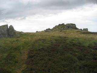
Wester tor, a rocky peak.
From Wester Tor the footpath runs south, there is a Trig Point on the left. At the fence line there are two gates at least. South West is Hare Law, another rocky peak, but we followed the fence line downhill and just east of south.
We did this walk on August 3rd, nine days before the start of the grouse shooting season. The one advantage of this for walkers is that the organisers of the shooting have managed to cut 12 foot wide paths in the heather to make it easier for the brave hunters to get to their shooting butts. These paths are springy to walk on and should be extended. At the end of the cut path, returning to the more usual footpath cross the fields to Commonburn House and take the track in front of the farm buildings which leads in a south east direction to Broadstruther, another hill farm.
However Broadstruther was left deserted and dilapidated for years until it was rebuilt and refurbished
as an R and R for tired grouse hunters. Closed today, we sat and had a drink and a sandwich.
 Broadstruther, hunters lodge.
Back on our feet we followed the well made track north east from Broadstruther. Watch out for a footbridge on the left and take it to join a footpath across open land, bracken infested land and eventually to another footbridge across the Carey Burn.
 Looking upstream at Carey Burn.
We are gadgie walkers,
We walk for miles and miles,
But now that we are older,
We use gates and don't climb stiles.
Follow the burn and at the first marker turn left up a steep wooded bank. This bank is called the Hell Path because it is towards the end of "The Chevy Chase" an annual walk or RUN of some twenty miles, a last cruel stretch before the end.
At the top of the hill follow the path across fields, take the signed path by the first house you come to and cross fields, go downhill and be back at the car park.
On the information board we spotted this small plaque:
 Look for this on the information board.
There have been a number of air crashes on and around the Cheviot, most of them in World War II
This plaque commemorates the dog who helped the shepherds rescue the crew of a Boeing B 17 Bomber which crashed in December 1944. Some remains of the aircraft can be seen not too far from the Cheviot summit.
There are several books on the crashes, one being:
Where the Hills Meet the Sky; By Peter Clark printed and published by Glen Graphics.
THE MATRIX
PED STEPS MILES
LIDL USB 27120 12.83
ASDA CURVY23104 10.94
HIGEAR 27902 12.667
OUTDOORS GPS 12.2
MEASURED ON MAP 12.1
12 and a bit really good miles seems reasonable.
On our way home we stopped to rehydrate at the Anglers Arms at Weldon Bridge, a favourite watering hole, friendly staff, great pub and dining room too but sadly the beer was a bit disappointing today. Taylors Golden Best. Ruddles Golden Best and Ruddles County. Non of them on top form, 3 barrels only today. Thank goodness I was the driver
Go, walking with the gadgies,
See hills and dales and farms,
And after miles of walking,
Relax in the Anglers Arms.
PS. My audience reads a bit like the Olympic medal table today, USA has most hits, UK second but nothing for China.!

Ambulo, ergo sum

Contains O.S. data Crown copyright and data base copyright 2012

(Not many torists out today)
I go walking with the gadgies,
We walk on hills and dales,
This year we went to Scotland,
Next year it might be Wales.
As I was about to leave the house, my wife (of 43 years and 1 day) said, with a hint of sarcasm,
"Look at you, your clothes are coordinated for once, grey trousers, grey T shirt and grey socks. Are you feeling OK?" How have we stayed together so long. Pure luck, I rarely care about these things.
There are four of us out today, the punmeister, the vogelmeister, the routemeister who has forgotten his map and me.
Today's walk is back on home territory in Northumberland, starting from Wooler and walking St. Cuthbert's Way to the Newton Tors. (And you thought it was a spelling mistake!)
To get to Wooler take the familiar A1, A697 and turn into the small country town.
We parked the car and headed for the main street to find a cafe for a bacon sandwich and tea. The establishment scored 3.5 flitches: the bacon was fine, the bun was better than usual, the tea was strong but a smile with the service would have been appreciated.
After breakfast we headed up Ramsey's Lane, almost directly opposite the Wheatsheaf Hotel, following the signpost for Wooler Common. There is, after about a mile, a car park with an information board.
A map is advisable, OL 16, The Cheviot Hills covers all this walk, and many more, and the starting point is GR 977272. St. Cuthbert's Way is clearly marked on the map, unless you have an old one.
Cross the stream by the footbridge and take the second footpath on the left which goes through a wood for a short distance before reaching a gate. Follow the footpath across a field to the first junction and take the path labelled St. Cuthbert's Way.
St. Cuthbert's Way is a 62.5 mile (100km) footpath from Melrose where the Saint started his ministry to Lindisfarne (Holy Island ) where he completed his work and died. It is well signposted with small white squares labelled "St. Cuthbert's Way and an arrow pointing, hopefully, in the right direction.
Visible to the north on this section of the walk is Humbleton Hill which has the stony remains of an Iron Age Hill Fort on the top, built around 300BC. Well worth a visit, but not today.
In 1402 the Percy's (Harry Hotspur) and Douglas's had one of their regular confrontations on Homildin Hill as it was then called. On this occasion Harry's team won. It gets a mention in Henry IV Part 1, a play by the English Bard.
After approximately 2.5 miles following the footpath in a westerly direction the route turns north west by the side of a wood. Today a line of bee hives was outside the wood. The heather is coming into bloom, the bees could be heard from yards away, we stayed clear.

I've done it all my life,
It makes the peas taste funny,
But it keeps them on the knife.
Beehives on St. Cuthbert's Way
Because the moors are used for grouse shoots there are many "unofficial " paths cut in the heather, but about a mile beyond the beehives turn west and walk gently uphill past a line of shooting buts to the first of the tors, Easter Tor.

Easter Tor was declared a Herbiespot and the usual lunch of sandwiches and pies was consumed, although the midges were a nuisance.
Looking north east from Easter Tor you can see Yeavering Bell, two small peaks with the remains of a hill fort enclosing both, and dating from about 500BC. Also well worth a visit, but not today.
North of Yeavering Bell is the site of the Anglo Saxon king's of Northumbria's palace at Gefrin, built about 600AD and abandoned about 100 years later. The word Gefrin has evolved to Yeavering, the hill is "The Hill of the Goats, and there are several small flocks of feral animals on the hillsides here.

Tors are usually associated with Devon and Cornwall in Britain, the word comes from the Gaelic torr, meaning rocky hilltop. Geologist, Geographer and Linguist, all in one.
From Easter Tor a footpath runs south west to Wester Tor, from whose rocky peak you have a good view of Hethpool below. The entrance to the beautiful College Valley and once home to Admiral Lord Collingwood who took over from Nelson at Trafalgar in 1805 when the latter was mortally wounded.

Far below us Heshpool stood,
A lovely house it war,
Once the home of Collingwood,
Who fought at Trafalgar.

Wester tor, a rocky peak.
From Wester Tor the footpath runs south, there is a Trig Point on the left. At the fence line there are two gates at least. South West is Hare Law, another rocky peak, but we followed the fence line downhill and just east of south.
We did this walk on August 3rd, nine days before the start of the grouse shooting season. The one advantage of this for walkers is that the organisers of the shooting have managed to cut 12 foot wide paths in the heather to make it easier for the brave hunters to get to their shooting butts. These paths are springy to walk on and should be extended. At the end of the cut path, returning to the more usual footpath cross the fields to Commonburn House and take the track in front of the farm buildings which leads in a south east direction to Broadstruther, another hill farm.
However Broadstruther was left deserted and dilapidated for years until it was rebuilt and refurbished
as an R and R for tired grouse hunters. Closed today, we sat and had a drink and a sandwich.

Back on our feet we followed the well made track north east from Broadstruther. Watch out for a footbridge on the left and take it to join a footpath across open land, bracken infested land and eventually to another footbridge across the Carey Burn.

We are gadgie walkers,
We walk for miles and miles,
But now that we are older,
We use gates and don't climb stiles.
Follow the burn and at the first marker turn left up a steep wooded bank. This bank is called the Hell Path because it is towards the end of "The Chevy Chase" an annual walk or RUN of some twenty miles, a last cruel stretch before the end.
At the top of the hill follow the path across fields, take the signed path by the first house you come to and cross fields, go downhill and be back at the car park.
On the information board we spotted this small plaque:

There have been a number of air crashes on and around the Cheviot, most of them in World War II
This plaque commemorates the dog who helped the shepherds rescue the crew of a Boeing B 17 Bomber which crashed in December 1944. Some remains of the aircraft can be seen not too far from the Cheviot summit.
There are several books on the crashes, one being:
Where the Hills Meet the Sky; By Peter Clark printed and published by Glen Graphics.
THE MATRIX
PED STEPS MILES
LIDL USB 27120 12.83
ASDA CURVY23104 10.94
HIGEAR 27902 12.667
OUTDOORS GPS 12.2
MEASURED ON MAP 12.1
12 and a bit really good miles seems reasonable.
On our way home we stopped to rehydrate at the Anglers Arms at Weldon Bridge, a favourite watering hole, friendly staff, great pub and dining room too but sadly the beer was a bit disappointing today. Taylors Golden Best. Ruddles Golden Best and Ruddles County. Non of them on top form, 3 barrels only today. Thank goodness I was the driver
Go, walking with the gadgies,
See hills and dales and farms,
And after miles of walking,
Relax in the Anglers Arms.
PS. My audience reads a bit like the Olympic medal table today, USA has most hits, UK second but nothing for China.!

Ambulo, ergo sum

Contains O.S. data Crown copyright and data base copyright 2012

No comments:
Post a Comment