Keep the sea on your right (April27th)
and you can't go wrong on this walk on part of the Northumberland Coast Path, provided you are walking north.
Several days of steady rain have persuaded the five gadgies out today that the hills will be soggy underfoot so we have chosen a coastal walk from Alnmouth to High Newton by the Sea.
The most scenic way to get to Alnmouth is to take the Coastal Route up the A189 which becomes the A1068 and turn right into Alnmouth at Lesbury, parking in the beach car park for a mere £1.50 for a whole day. A map is not essential but the route is covered by OS332 and the car park is at GR250106. But bear in mind that the walk is a linear one of 12 miles and you may have to make arrangements to return to Alnmouth. There is a bus service from High Newton to Alnmouth but I am not prepared to give information on that except that it is the 501 to Newcastle and does not run very frequently.
There are five gadgies out today, punmeister, vogelmeister, halfmarathonmeister,inviteemeister Bob and me, blogmeister
Alnmouth is a pretty little village, not surprisingly at the mouth of the River Aln. A medieval port it grew steadily until 1806 when a violent storm changed the course of the river and the port slipped into decline as the river silted up. Now it seems to be a genteel holiday resort with a golf course by the sea. and several attractive hotel and pubs.


We caught the 16.26 bus (501) outside the pub, flashed our gadgie passes and headed for Alnmouth.
and you can't go wrong on this walk on part of the Northumberland Coast Path, provided you are walking north.
Several days of steady rain have persuaded the five gadgies out today that the hills will be soggy underfoot so we have chosen a coastal walk from Alnmouth to High Newton by the Sea.
The most scenic way to get to Alnmouth is to take the Coastal Route up the A189 which becomes the A1068 and turn right into Alnmouth at Lesbury, parking in the beach car park for a mere £1.50 for a whole day. A map is not essential but the route is covered by OS332 and the car park is at GR250106. But bear in mind that the walk is a linear one of 12 miles and you may have to make arrangements to return to Alnmouth. There is a bus service from High Newton to Alnmouth but I am not prepared to give information on that except that it is the 501 to Newcastle and does not run very frequently.
There are five gadgies out today, punmeister, vogelmeister, halfmarathonmeister,inviteemeister Bob and me, blogmeister
Alnmouth is a pretty little village, not surprisingly at the mouth of the River Aln. A medieval port it grew steadily until 1806 when a violent storm changed the course of the river and the port slipped into decline as the river silted up. Now it seems to be a genteel holiday resort with a golf course by the sea. and several attractive hotel and pubs.
Watch out for flying golf balls in Alnmouth.
The footpath from Alnmouth is very easy to find. It follows the coast heading north, mostly on the beach passing points with interesting names, Bally Carrs and Marmouth Scars, , Boulmer Haven and Bewick Stone to mention but four. The first pub is at Boulmer itself, although we nobly passed it by. Boulmer is home to the RAF helicopter station and it used to bristle with radar aerials watching out for invaders from the east.
Continue on the beach, watching for the sea birds, of which there are many, including a couple of gannets who might have suffered in the recent high winds and a guillemot which had come to the same sad end. All three had lost their eyes to crows.
We made a Herbie stop at the Howick Burn, some 4.5 miles from our start and just after the points marked Sugar Sands and Iron Scars on the map.
It used to be possible to park near Howick and walk through Cushat Wood to this point but that path seems to have been closed.
Just above the Howick Burn is an ancient settlement and a short way north is the site of what has been described as the oldest house in England, a Mesolithic home, rather like a teepe. After an archaeological survey a replica house was built in 2003 but sadly it was blown over in a storm although the circular base remains.
"Didn't last as long as the original," said Ben

The information board at the site of England's oldest house.
The next part of the walk has been covered before but that was bound to happen eventually. More interesting names as we approached Craster, Rumbling Keys,
Black Hole and the very interesting Hole of the Dike. Near this one a dike of dolorite emerges from the land and makes a straight line for the sea. A dyke is a vertical intrusion of volcanic rock, as opposed to a sill, a horizontal intrusion and useful for building castles on in Northumberland. Interesting: Americans spell the word as dike, so why "The Hole of the Dike"?
Craster is the home of the kipper, a slowly smoked herring, usually eaten by Englishmen for breakfast.

The harbour at Craster; the tide is out. The building on the end of the pier was used for loading whinstone chippings from a nearby quarry.
*
Craster is another pretty Northumbrian fishing village but its main attraction for me is the approach to the ruined Dunstanburgh Castle about a mile north of the village.
The writers of Pevsners " Northumberland "* say it is one of the most moving sights in the county and who could disagree. Approached across a grassy slope kept neatly cropped by sheep the castle was started in 1314 by Thomas, Earl of Lancaster. John of Gaunt made alterations in 1380 before he lost his horse shoe in Lancaster. The castle fell into ruin although most of the giant gatehouse remains, but only the foundations of the barbican which was outside the gatehouse.**

Dunstanburgh Castle behind its defensive gorse.
The main feature on the west side is the Lilburn Tower. There is a village called Lilburn in Northumberland near Wooler but I do not know if there is a connection. And of course John Lilburn of Leveller*** fame was 17th century character so it wasn't his.

The Lilburn Tower at Dunstanburgh Castle.
Beyond the castle, still heading north, is Dunstanburgh Castle Golf Course, so watch out for flying golf balls.
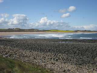
On the seaward side is a fine example of an anticline, illustrated in a previous walk, and also the sweep of Embleton Bay, sandy and beautiful with more interesting names, Jenny Bells Carr and Scadpallet.

Embleton Bay, this picture needs cropping to get
rid of the boulders in the foreground.
And at the north end of the bay is Newton by the Sea, another pretty fishing village, complete with a pub, the Ship Inn, and a Nature Reserve behind it. At this point we headed inland for High Newton by the Sea and the Joiners Arms. We were made very welcome by the new management and I enjoyed a couple of pints of Mordue's "Workie Ticket"**** . Chatting idly in the sunshine as we sat outside the pub, Dave asked if we knew a footballer called Wiley, I might have been tired after 12 miles but still had the wit to quip;
"Yes, I saw Stanley Matthews, he was a wily footballer"*****

The Joiners Arms at High Newton. Great pub, good beer.
We caught the 16.26 bus (501) outside the pub, flashed our gadgie passes and headed for Alnmouth.
But the walk was not quite over. The vogelmeister who also prides himself as a timetablemeister said we should get off at Hipsburn, as the bus didn't go into Alnmouth, and walk the mile back to the car, which we did. A few hundred yards down the road we were passed by the same bus which had gone to Alnmouth Station and turned round before heading for the village. It did not matter, it was a flat and pleasant walk on the riverside to the beach and the car.
I had bought, at great expense, (69p) a new App called ifootpath which was going to track our walk and draw maps and show distance and everything. It will be my fault, I never read manuals, and it failed.
Reliable Higear said 12 miles and so did Ben's bragometer. I wait Dave's calculations.
This is another excellent walk, obviously pretty level, but walking on sand can be quite tiring.
* Pevsner. A series of books on the buildings of England. Originally written by Nikolaus Pevsner, the Northumberland one has been updated by four writers.
** My sister has taken up an interest in barbicans so I mentioned it.
*** John Lilburn: olonel in Cromwell's New Model Army and one of the advocates of greater democracy. Not too popular with Cromwell afyter that.
**** Workie Ticket: North East dialect word for a trouble maker or awkward customer
***** Stanley Matthews, my first footballing hero. Played for Blackpool and Stoke City (and England). Famous for his skill at rounding defenders with his dribbling skills and bursts of speed. Remembered for the "Matthews Final" of 1953 when Blackpool came back from being 3-1 down to win 4-3. First game I ever saw on TV, a small black and white set, probably with a 10inch screen.
Stop Press
Dave has sent pedometer readings average of 9.25.
Measured walk:11.1 miles
Stop Press
Dave has sent pedometer readings average of 9.25.
Measured walk:11.1 miles
No comments:
Post a Comment