Brian's Round - a walk in Lauder Country
December 9th
Long ago the land north of the Humber was an Anglo - Saxon Kingdom. One of the Saxon Earls was blessed with identical twin sons, Egwulf and Eadwulf. So excited was he that he forgot which of the two boys had actually been born first so when he grew old, knowing that his time was almost up he divided his land between the two boys, rather than have them fight over their inheritance. One son set up in what became Eglingham, a village we walked from two weeks ago (Jenny's Lantern) and the other built his home in Edlingham. This division of land happened in other parts of Saxon England too. In Lancashire there are the villages of Yealand Redmayne and Yealand Conyers and in Somerset there are Midsomer Norton and Midsomer Murders. Everything was fine, the Saxon villagers of Edlingham began to build a church in the Saxon style: then, in 1066, the Normans came and spoiled everything, but they did add to the church which, after some repair and rebuilding still stands.
Today's walk starts and finishes in Edlingham; it is called Brian's Round because the punmeister found it on his ROM, whatever that is and said if it was a poor walk we could blame him.
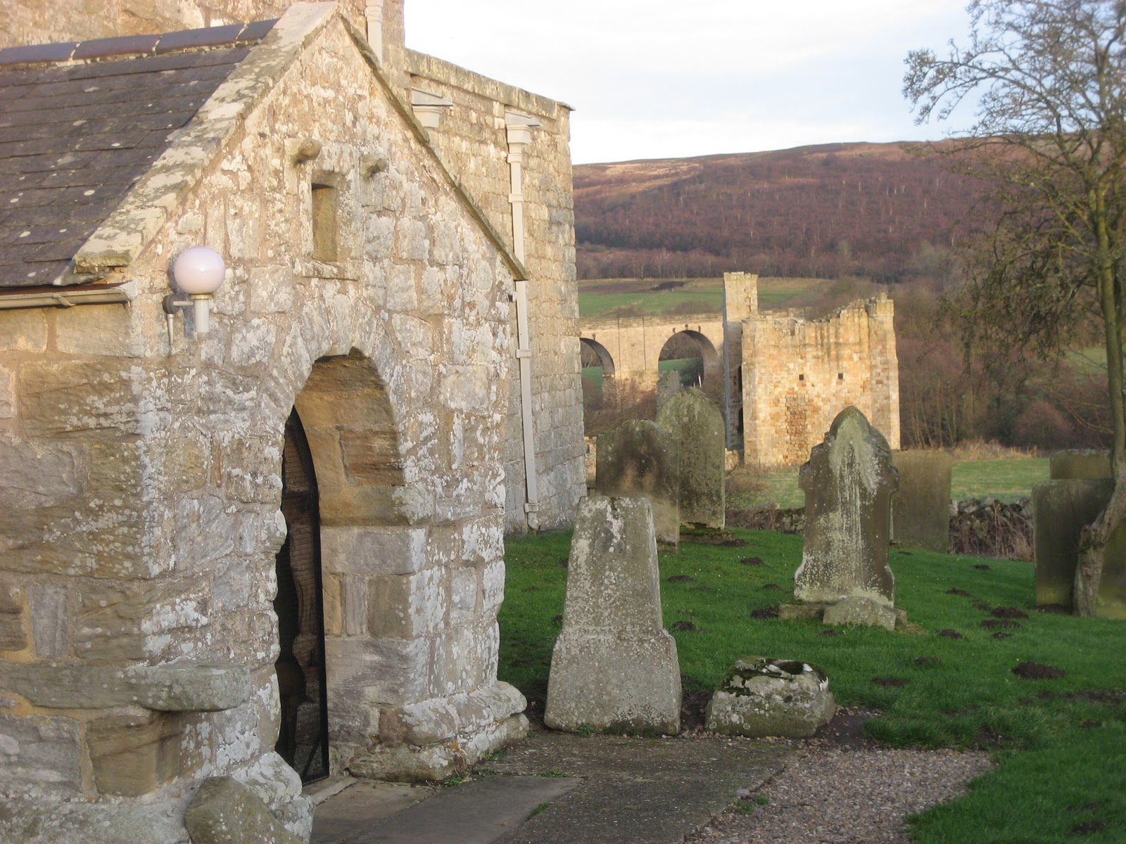
To get to Edlingham from Newcastle head north on the A1, turn off on the A697 at Morpeth and follow that road to the B6341, turn right, after a mile or so turn left down a minor road into the village. There is some parking near the church. The three local landmarks are clearly visible; the church, dating in part as far back as 1050, the ruined castle ,built about 1295 by Sir William Felton and the railway viaduct, about 1885, that linked Alnwick with Wooler and beyond. Using OS Explorer Map 332, the church is at GR114091.

The Church of St. John the Baptist, the castle and the railway viaduct in Edlingham.
Leaving the church walk through the village past the Demesne* and at the finger post turn left and cross a field. Cross a second, diagonally and then a third. You are walking close to, or occasionally on a Roman road, the Devil's Causeway which branches off Dere Street north of Corbridge and goes to Berwick upon Tweed . Romans north of the wall, looking for the lost legion probably.* * Wearing his archaeologist's hat Dave reckoned the stones at the side of the field were probably the remains of the agar, the edge of the road.
Cross a footbridge (not Roman) and walk up to the road. (B6341) Cross the road, through the gate and follow the path across moorland, or take the easier green path, to the edge of the coniferous forest. Take the track through the wood and emerge at Wellhope.
There was a time when the family who live at Wellhope lived most of the year in a Teepee, clearly visible from the A697 as you drove to Wooler. I believe the head of the household was a stonemason and his wife taught jewellery at local evening classes. They seem to have moved into the cottage. The footpath from Wellhope runs along a fence line and then through the wood until it emerges onto moorland. Head approximately South East for Snook Bank, taking the time if you wish to search for "cup and ring marks" on rocks.***
 An example of Cup and Ring markings. Not the ones on this walk, but there are quite a few in Northumberland.
Snook Bank was chosen as a Herbie Spot. Tucked behind a wall to shelter from the chilly breeze, and with a mouse for company, we ate lunch, including the now obligatory pork pies.
The track from Snook Bank crosses a field and joins a lane which goes to Glantless Farm. Just before the farm take the path across fields to a minor road. Although it was a cold and dry day there had obviously been some heavy rain, the field was muddy. one of the rules for a Lauder walk. It sticks to your boots, slows you down and elicits much cursing, particularly in gateways. Cows have a habit of congregating at gates, churning up the ground so that all grass disappears and all that is left is mud. Walks could be a lot more pleasant without farm animals. However we saw two buzzards in the area, out looking for lunch.
Turn left on the road and follow it through Shiel Dykes. Just beyond Shiel Dykes on the left is a small pond with platforms for fishing and a large scarecrow to frighten off passing Ospreys. And beyond this, on a south facing slope is a well ordered plantation, possibly raspberries, or even vines. Stay on the track for about a mile from Shiel Dykes before taking a path on the left that leads Phyllis's Plantation. The field consists of muddy ground and tussocks, another ingredient for a Lauder Walk. The path goes through the plantation but it is easier to walk round it and struggle upthe hill to Mare's Rigg. On the way up the slope we disturbed an owl, probably a barn owl. Through the gate more tussocks and then heather, the final Lauder ingredient, hard work at times but heather cleans your boots. Down the hill to the road, turn right, after about a quarter mile turn left and soon you are back in Edlingham.
Pedometers were not too well behaved today, the Higear opened at some point and when this happens it does not work properly. The Little Black Number fell off my belt but, having adopted the Dave Kear loop of thread safety system (LOTSS) I didn't lose it. The walk turned out to be about 9.5 miles, relatively easy going in spite of the Lauder conditions. Brian's Round proved to be a good winter walk, worth repeating.
On the way home we were welcomed as regulars in the Anglers Arms at Weldon Bridge but I must admit to drinking only tea, my sexuality is now in doubt. But I was driving.
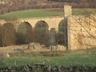
Castle and viaduct in the evening light.
 Five of the ancient monuments in Edlingham. From the left: Ray, Harry, St. John's church, viaduct and castle.

*By request: Demesne is that part of the land exclusively for the use of the lord of the manor. Not that he would go out planting his turnips of course, the peasants would have to do that for him.
December 9th
Long ago the land north of the Humber was an Anglo - Saxon Kingdom. One of the Saxon Earls was blessed with identical twin sons, Egwulf and Eadwulf. So excited was he that he forgot which of the two boys had actually been born first so when he grew old, knowing that his time was almost up he divided his land between the two boys, rather than have them fight over their inheritance. One son set up in what became Eglingham, a village we walked from two weeks ago (Jenny's Lantern) and the other built his home in Edlingham. This division of land happened in other parts of Saxon England too. In Lancashire there are the villages of Yealand Redmayne and Yealand Conyers and in Somerset there are Midsomer Norton and Midsomer Murders. Everything was fine, the Saxon villagers of Edlingham began to build a church in the Saxon style: then, in 1066, the Normans came and spoiled everything, but they did add to the church which, after some repair and rebuilding still stands.
Today's walk starts and finishes in Edlingham; it is called Brian's Round because the punmeister found it on his ROM, whatever that is and said if it was a poor walk we could blame him.
To get to Edlingham from Newcastle head north on the A1, turn off on the A697 at Morpeth and follow that road to the B6341, turn right, after a mile or so turn left down a minor road into the village. There is some parking near the church. The three local landmarks are clearly visible; the church, dating in part as far back as 1050, the ruined castle ,built about 1295 by Sir William Felton and the railway viaduct, about 1885, that linked Alnwick with Wooler and beyond. Using OS Explorer Map 332, the church is at GR114091.
The Church of St. John the Baptist, the castle and the railway viaduct in Edlingham.
Leaving the church walk through the village past the Demesne* and at the finger post turn left and cross a field. Cross a second, diagonally and then a third. You are walking close to, or occasionally on a Roman road, the Devil's Causeway which branches off Dere Street north of Corbridge and goes to Berwick upon Tweed . Romans north of the wall, looking for the lost legion probably.* * Wearing his archaeologist's hat Dave reckoned the stones at the side of the field were probably the remains of the agar, the edge of the road.
Cross a footbridge (not Roman) and walk up to the road. (B6341) Cross the road, through the gate and follow the path across moorland, or take the easier green path, to the edge of the coniferous forest. Take the track through the wood and emerge at Wellhope.
There was a time when the family who live at Wellhope lived most of the year in a Teepee, clearly visible from the A697 as you drove to Wooler. I believe the head of the household was a stonemason and his wife taught jewellery at local evening classes. They seem to have moved into the cottage. The footpath from Wellhope runs along a fence line and then through the wood until it emerges onto moorland. Head approximately South East for Snook Bank, taking the time if you wish to search for "cup and ring marks" on rocks.***
Snook Bank was chosen as a Herbie Spot. Tucked behind a wall to shelter from the chilly breeze, and with a mouse for company, we ate lunch, including the now obligatory pork pies.
The track from Snook Bank crosses a field and joins a lane which goes to Glantless Farm. Just before the farm take the path across fields to a minor road. Although it was a cold and dry day there had obviously been some heavy rain, the field was muddy. one of the rules for a Lauder walk. It sticks to your boots, slows you down and elicits much cursing, particularly in gateways. Cows have a habit of congregating at gates, churning up the ground so that all grass disappears and all that is left is mud. Walks could be a lot more pleasant without farm animals. However we saw two buzzards in the area, out looking for lunch.
Turn left on the road and follow it through Shiel Dykes. Just beyond Shiel Dykes on the left is a small pond with platforms for fishing and a large scarecrow to frighten off passing Ospreys. And beyond this, on a south facing slope is a well ordered plantation, possibly raspberries, or even vines. Stay on the track for about a mile from Shiel Dykes before taking a path on the left that leads Phyllis's Plantation. The field consists of muddy ground and tussocks, another ingredient for a Lauder Walk. The path goes through the plantation but it is easier to walk round it and struggle upthe hill to Mare's Rigg. On the way up the slope we disturbed an owl, probably a barn owl. Through the gate more tussocks and then heather, the final Lauder ingredient, hard work at times but heather cleans your boots. Down the hill to the road, turn right, after about a quarter mile turn left and soon you are back in Edlingham.
Pedometers were not too well behaved today, the Higear opened at some point and when this happens it does not work properly. The Little Black Number fell off my belt but, having adopted the Dave Kear loop of thread safety system (LOTSS) I didn't lose it. The walk turned out to be about 9.5 miles, relatively easy going in spite of the Lauder conditions. Brian's Round proved to be a good winter walk, worth repeating.
On the way home we were welcomed as regulars in the Anglers Arms at Weldon Bridge but I must admit to drinking only tea, my sexuality is now in doubt. But I was driving.

Castle and viaduct in the evening light.
 Five of the ancient monuments in Edlingham. From the left: Ray, Harry, St. John's church, viaduct and castle.
Brian's Round (Below)
*By request: Demesne is that part of the land exclusively for the use of the lord of the manor. Not that he would go out planting his turnips of course, the peasants would have to do that for him.
** The IX legion. Marched off to Scotland and were never seen again. The Eagle of the Ninth a children's novel by Rosemary Sutcliffe was filmed a few years ago as The Eagle
*** Cup and ring marks. Probably dating from Neolithic times and found not only in Northumberland but in other areas of Europe and also in Mexico. Nobody is sure of their exact purpose, religious, writing or art work?
I have been a little worried about the lack of Russian readersthis week. They have probably been too busy, what with voting, counting and protesting, but there have been three hits this week.
Спасеба.
No comments:
Post a Comment