Translate

Thursday, 3 October 2013

Walking with the Gadgette III and Where Eagles don't Dare.    Sept 27th.

  On September 23rd the gadgette and I left for a week's holiday on the beautiful island of Madeira which meant I would miss the gadgie walk of the 27th.
The hotel we stayed in obviously recognised we had class, low in my case, as they upgraded us from a room to an apartment which consisted of a living room, a bedroom, kitchen and dining area, plus two bathrooms!
 The room was on the fourth floor overlooking the pool. The view provided us with much early morning entertainment as we watched people emerge from their rooms, put towels on sun loungers and retreat to their breakfasts, in spite of the notice, in Portuguese, English and German, stating that it was not permitted to reserve  loungers. I suspect the rules were broken by Germans.
                                             Reserving loungers verboten est!
We had planned a relaxing week, with gentle walks and trips by public transport. First we made a trip on my wife's favourite terror ride- the bus journey to Curral des Freras, the Valley of the Nuns. The road is narrow, steep and winds up the sides of the valley. Should the bus go over the low looking barrier it would undoubtedly fall for several hundred feet in places.
                                   Taken from the bus, and not the steepest part by any means
There is not a lot to do in the village apart from admire the view. But the highlight of the day was the visit to the Information Centre/Bank in the centre of the small collection of souvenir shops and cafes.
I called in to ask about buses back to Funchal. The man cheerfully told me that today it was a bank, not an information centre. Bank on Tuesdays and Thursdays, he explained, Information on Wednesdays and Fridays, no info today, it's Tuesday. That's fine, I told him, but could he please tell me bus times.  Of course he could, and did, although it was a bank. What would happen if you wanted cash on a Wednesday or Friday?
                                           Curral des Freiras
                                                     Looking down the valley
                                                       The flimsy barrier.
  Most evenings I wandered down to "the spa" in the hotel to sweat it out in the sauna and steam room before enjoying a pummelling in the super sized Jacuzzi and a short swim.
Most evenings I was joined by a huge Russian who told me worked "in security". I suspect he wore a suit and sunglasses at work and no doubt had a bulge in his side pocket. He told me he loved England and had visited most of the tourist sites but really wanted to go to the town where  "the beee-attles" came from, Liverpool. He was overcome with emotion when I told him my wife and I had seen them way back in 1966! In return I told him of my visits to St. Petersburg and Moscow but left out the bit about going to the post office which didn't have any stamps.
Another day we went to the bus station and got on the first bus leaving, just to see where it went. We finished up in Canico, pronounced Caniso. Not a lot there but we joined a group of  four Netherlanders for a taxi ride back. The lady driver gave us a guided tour, carefully explaining the economy of the island, which nation sent most tourists, (Germany) and how the place had recovered from the floods. "Thank you, all you Germans, Dutch and English for funding us through the EU!". So the Union has some fans.
On the last day we set off to walk a levada. As we left the hotel the heavens opened, causing a rapid change of mind, Instead we caught an open topped bus, and before you even think what's the point if it's raining, the front section had a roof! The bus had a twelve language commentary, accessible by earphones (supplied). We sat next to a German couple who were very friendly and explained how the system worked. The American voice (why) told us all about banana and wine production and the fishing village of  Camara de Lobos. I noticed our new German friends went quiet when the voice explained that British Prime Minister Winston Churchill came to Camara de Lobos to paint. Maybe he's not too popular in the fatherland. The voice also told us about the rich flora and fauna on the Island Desertas, visible but inaccessible from the mainland, they are nature reserves. Made you want to go really to see the birds, flowers and seawolves.
                                                 Lizards are common all over the island
                                              Slightly off the tourist track in Funchal
                                            Zarco who discovered the island. Christopher
                                            Columbus lived on neighbouring Porta Santos
                                            for a few years before his wife told him to clear
                                           off and find something new. He did, America.


                                        Torrential rain in 2010 caused much damage in Funchal,
                                        millions of Euros are being spent repairing and improving the
                                        sea front.


MEANWHILE BACK IN THE UNITED KINGDOM..............................
My fellow gadgies had the usual Friday out. Brian gave me this report.


WHERE EAGLES DON’T DARE – Friday 27th September 2012


Today’s walk is around the head of Haweswater.  This is on the eastern side of the Lakeland fells so doesn’t require a visit into Keswick. Instead follow the A6 from Penrith to Shap where you turn off to the right following the signs to Brompton and then Haweswater.

 Not going into Keswick we breakfasted at the Village Bakery in Melmerby.  Bacon sandwiches 5* fitches and excellent toast and honey.  On to Haweswater where there is a small car park (469107), for which there is no charge and which we were surprised to find was almost full.


Haweswater is a reservoir constructed in controversial circumstances, read something of its development at http://en.wikipedia.org/wiki/Haweswater_Reservoir, but its southern end matches the grandeur of the head of Ennerdale.


There are 5 gadgies out today, Ben, Harry, Dave, John and Brian.  Your beloved author is spending time in Madeira with his gadgette. 


The rough route of the walk is to Gatesgarth Pass – Harter Fell – Nan Bield Pass – Mardale Ill Bell – High Street – Kidsty Pike – Car Park.


The walk up to Gatesgarth Pass is a demanding ascent though the track is good underfoot.


Route up to Gatesgarth Pass


 At the top of Gatesgarth turn right and head up to the top of Harter Fell.  As it was now a beautifully sunny day there was no problem reaching the summit and the views were fabulous.


Haweswater from Harter Fell


 The summit is marked by a large pile of stones adorned with a tangled array of what look like old fence posts.


We now descended down to Nan Bield Pass where there is an excellent shelter of which we availed ourselves for a Herbie stop.  Ben provided his top notch ginger biscuits and John chipped in with some chocolate cookies.  Whilst having lunch a couple approached up the direct path from Haweswater and were ready to return by the same route until Dave and Harry recommended the route we had come up for their return.  They seemed pleased with this suggestion.


After lunch there is a steady climb over Mardale Ill Bell, with views to the west over Kentmere reservoir and out to the coast, to the flat summit of High Street.  High Street (828m) is named after a roman road which ran over it.  Why over and not around, stand on the summit and you’ll understand.


The descent from High Street around to Kidsty Pike takes you across the head of Riggindale. 


Kidsty Pike & Riggindale


This is a wide valley with crags on the southern side and grassy slopes with some scree on the northern side and with nothing much going in between.  Or is there?  Take a closer look and you are likely to see a herd of red deer and then two, three and more.  In total we estimated there would be about 100 in the valley.  They were in distinct male and female groups.  It will be coming up to rutting season for the males where they battle each other for the right to take females out and wine and dine them at the best streams and then perhaps a little more afterwards…..


The valley is also the home of England’s only Golden Eagle.  The RSPB website suggests that it is still there. It is a male, whose female died nine years ago and it waits in lonely solitude for a new female to turn up.  Ben and Brian are RSPB members but even that didn’t persuade it to put in an appearance.


The descent from Kidsty Pike is fairly gentle and pleasant walking and on the way back Dave Ben and Brian called in at the RSPB eagle observation point.  Another 0.75 miles saw us back at the carpark.


Looking up Haweswaer


We returned via Askham – a lovely village – where we took beer in the Queens Head.  This is a pub as it should be; welcoming, good décor and excellent beer. Five barrels awarded.


The bar of the Queen’s Head

Stats.


Dave’s Pedometer          9.7

Brian’s GPS                         8.9

Ben’s GPS                            9.0


Bird of the Day


The English Golden Eagle


Beast of the Day


Red Deer Stag

Brilliant.


Friday, 20 September 2013

Oh Brian, where art thou?     Sept.20th
 
  After last week's walk in the Lake District we have opted for an easier local walk today. There are six of us out today, John, Harry, Ben, Brian, Dave and me. The walk is a variation of "Belford" from about two years ago and not surprisingly it starts in the small Northumbrian town of Belford which is easy to find. From Newcastle head north on the A1 until, beyond Alnwick, home of the Duke of Northumberland, and turn left at the signpost for Belford. There is a small café, The Well House, which serves a first class bacon sandwich in a choice of bun, with brown sauce if requested, and tea served in a willow pattern teapot and drunk from delicate cups with the same design. Everybody's granny had willow pattern tea sets!.
  We left the cars outside the Belford Community Club at  GR NU 106338. The walk is covered by OS Outdoor Leisure Map 340, Alnwick.
                                                      Preparing in the park.
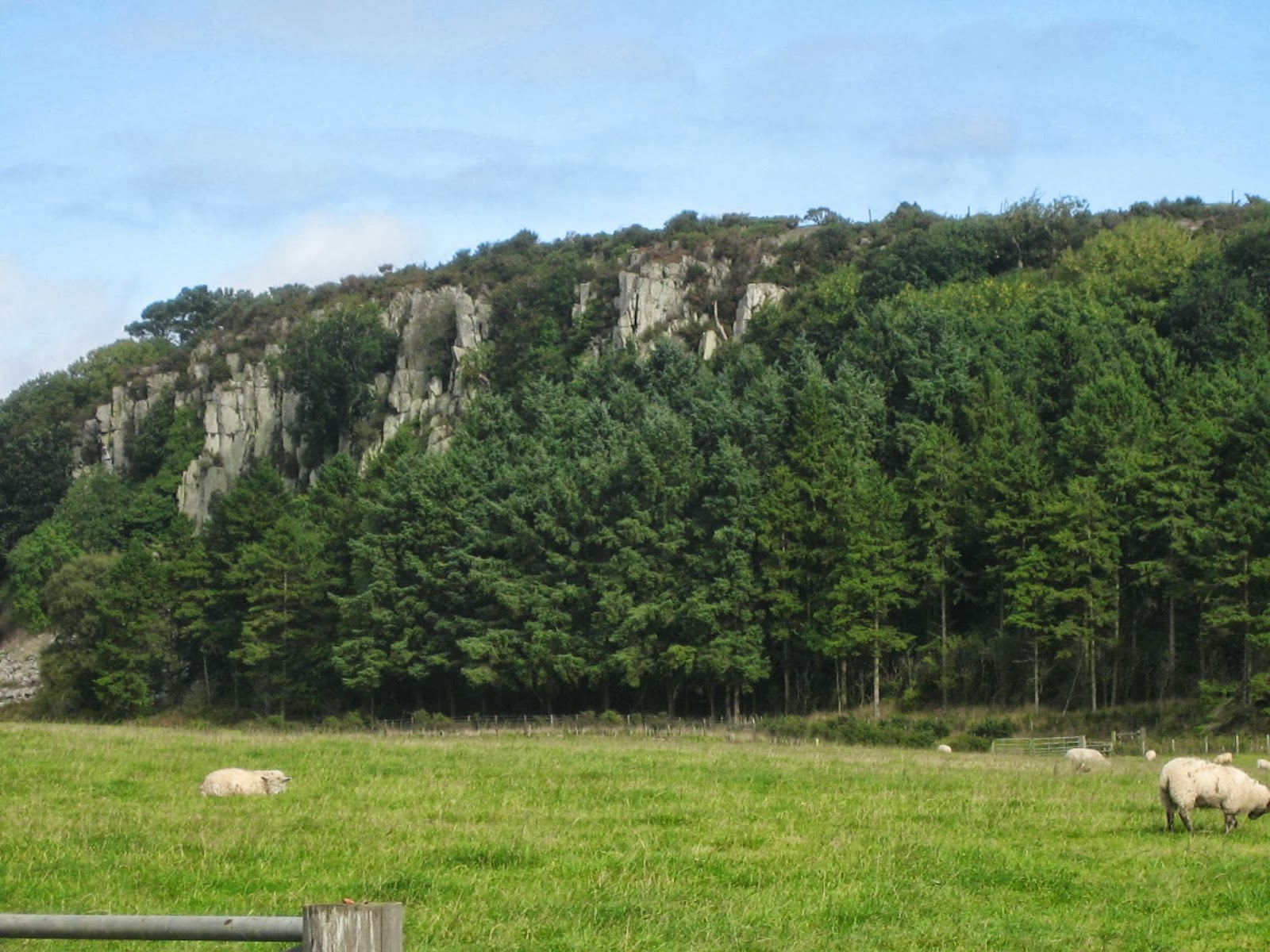
  We took the lane on the left hand side of the club and walked towards Craggy Hall. This time of the year the hedgerows are full of blackberries, it is a good year for them , wet and warm. On the right hand side of the lane near Craggy Hall are some quite impressive crags, hence presumably, the name. Ben, who has an interest in geology, explained their formation and later even produced a geological map of the area. I should listen more carefully, then I could explain these extrusions. (1 mile)
  After walking through a wooded area we came to a junction and realised Brian was no longer in sight, he had walked ahead from the start. Having done this walk before we knew he would have turned left and so did we, following the lane until we came to the farm at Swinhoe.
                                                         Impressive crags
                                                            And a lime kiln.
  At Swinhoe we turned right and headed north west along  the lane towards Swinhoe Lake. (2m)
                                   The swans of Swinhoe. Swinhoe means "swine hill" Belford,
                                   surprisingly, may come from Bel-Haga Old English for
                                     forest glade or dry land in a swamp.

                                                 Gadgies in a glade. England in Autumn!
 Leaving the woods around the lake we came across open ground  (3m) which afforded a superb view towards the sea and Holy Island.
                                                         My pocket camera is not good enough
                                                      for seascapes but this is Holy Island!
Soon we were back in woods again, Shiellow Wood to be precise  but when we emerged into open land at Ravens Crag which gave us a panoramic view of the Cheviots we made a Herbie Stop (5m)although there was still no sign of Brian. A couple who were also having lunch said they had seen a man fitting his description striding out, sounded like Brian.
Fortunately I had remembered chocolate this week and we had Ben's superb home made ginger biscuits too.  Lunch over we continued on our way over the grassy moorland. Should you follow this walk take the right fork near Holburn Moss, a small lake teeming with teal, and climb up to the ridge. A trig point (6m) tells you you are heading on the right direction.

 But do stop to admire the Cheviots.
                                                  Not so distant Cheviots
                                                        Holburn Moss.
   Not far from the trig. point we crossed a style, climbed the short distance to a cairn and followed a path across fields until we hit the woodland near Swinhoe Lake again. We retraced our steps to the farm (8m). At the farm we followed the sign post that led us past the riding school, across fields and back to Belford, the path being well marked with
                                                St. Oswald was here.
                                                        Westhall, possibly a peel tower.
When we arrived back in Belford we noticed Brian's car had gone. And at that moment my phone informed me I had an email. It was from Brian, he had completed the walk by 2.30 and gone home as he had an evening appointment in a pub. He had however left us some of Mrs As home made chocolate digestives tucked into the door handle of Harry's car.
To finish the day we called in at The Salmon Inn in Belford which served Hadrian Brewery Coast to Coast.   Four barrels because it was the only real ale, although it was in good nick!

Matrix  MMMCV

                                                         steps                                           miles
ASDAPED                                     17740                                          8.33
LIDL3D                                          10311                                          4.63 Failed again

DavesLIDL3D                               20284                                            10.24  This is unfair
LIDLUSB                                      20184                                            10.19

OUTDOORGPS                                                                                     9.72
Brian's GPS                                                                                            10.2
Ben's bragometer                                                                                    9.77

Bird of the blog
Has to be the teal, there were so many, although we also saw swallows, martins buzzards, pied wagtails swans and mallards.
Beast of the blog, reported by Brian, a slow worm or legless lizard, and we've all been there.

Monday, 16 September 2013


Bessyboot and Allen Crags......Friday13th Sept.


  Friday September 6th was so wet we cancelled the gadgie walk. This would never  have happened when we were younger, but when you are pushing seventy a wet day on the hills, or anywhere else is not so inviting.

There are five of us out today, Brian, Harry, Dave, John and me. A quintet of gadgies.

  Friday the thirteenth of September would, according to our local jock weatherman, be cloudy but dry, and not too cold so we opted for the Lake District, planning to walk up Glaramara by way of Bessyboot. The walk starts at Seatoller which is a hamlet in Borrowdale, just before the road begins to climb up to Honister Pass.  Directions from Newcastle are simple: A69, M6 south, A66 to Keswick and follow the road signs to Borrowdale on the B5289. Membership of the National Trust is an advantage at Seatoller as parking is free with your NT card, otherwise it costs £6.50 for the day.

 Of course we stopped at The Coffee Lounge in Keswick (First car park you come to in the town.) for breakfast, it still deserves five flitches for its bacon sandwich.

The Lake District has had a bit of a bad press this week. A man called George Mobius (or something) has said sheep farming should be banned on the fells as the sweet little Herdwicks overgraze and the area should be left to return to its natural state. I am told he writes for The Guardian, which explains a lot. With a name like Mobius he should be banned! (Mathematical joke).

Jeremy Clarkson, who writes for The Sunday Times maintains the Lake District is inhabited by bearded vegans who live in tents. There are two of us with beards, none of us are vegan although Ray is a vegetarian and we have camped in the Lake District so maybe he has a point. The Sunday Times used to be a good newspaper but has become obsessed with celebrity and money, filling many of its pages with tales of show business folk and rich Russians buying up London.

Moaning over, the walk: OS map OL4 The English Lakes North West Area covers the whole walk and the car park is at  NY 245137
                                 Yet another in my series on carparks. No charge
                                 for NT members, £6.50 otherwise.

  We left the car park and headed back towards Keswick, passing Glaramara hotel/outdoor centre on the left and the short row of whitewashed houses at Mountain View. Beyond them, on the right hand side of the road, near the campsite we took the footpath across the field that brought us out through a farmyard and close to the Stonethwaite church, St. Andrew’s. We turned right and walked past the school.
St. Andrews church porch Stonethwaite.

New Feature; this is the first mile of the walk. (Thanks to OUTDOOR GPS) and so far it has been level.

  We passed the Stonethwaite Country Hotel and bar and close to the campsite, on the right, found the gate that would lead us up to Bessyboot. The gate is not signposted but it led us to a very steep path up the Little Stanger Gill on the north west side of Bull Crag. If you follow this walk be warned, the path has been beautifully “stepped” but is very steep and seems to go on for ever and there is a little exposure in some parts. (2 miles) We followed the path, crossing the gill quite high up and eventually emerged on the west side of Bessyboot. After a bit of dithering we scrambled to the peak. (3 miles)

Looking down on to Stonethwaite Beck.
Note how well framed the fields are by the overhanging
branch! Could make the BBC Look North Calendar!
On the top was a young man (relatively young)) with a large pole attached to his rucksack and what was obviously a radio aerial, plus a walkie talkie set. Naturally we asked what he was doing. He was a member of a group called Wainwrights on Air or something similar. His job was to intercept messages from fellow members who were on the peaks of any of the hills mentioned in the great man’s books as verification of their ascent. Walking with a wireless! Sounds fun.
Dave discusses radio frequencies with Heathrow man as Harry looks on.
This picture for young Cathy from Grimsby.
 

  He worked at Heathrow but, not surprisingly, loved to get away to the Lake District. He promised to keep telling his friends in the south that the north of England was a land ruined by wet weather and a countryside besmirched by coal mines and shipyards, not to be visited. What a nice young man.

Having made all the jokes we could about Bessyboots, all clean and mainly involving Bessy Braddock, one time feisty MP, and Bessy Boothroyd, Blue Bell dancer and colourful Speaker of the House of Commons we continued on our way south across, or round, Rosthwaite Fell before heading south west towards Glaramara. (4 miles) We passed the Tarn of Leaves, which unfortunately gave me an Uhrworm for the day: The Talking Leaves, from Johnny Cash’s Album Bitter Tears, songs of the American Indian. Johnny was proud of his Cherokee blood he stated on the album, only to later admit that the claim was made to help sales.  At some point we  thought we heard a cry from Herbie so stopped for lunch which consisted of the usual, but I forgot the chocolate and Mrs A had not sent biscuits, Dave had not brought flapjacks either. The paths here are indistinct, if they exist, until we found the main one that leads up from Thornythwaite.
                       Tarn of leaves, Langdale Pikes in the right background


  Approaching the summit of  Glaramara is a rock step some twenty feet high which provides a nice little scramble. There is a way round it to the right.

Once on the summit we looked around: Glaramara (5 miles) is not one of the highest peaks but gives exceptional views of many of the Lake District hills, making the effort worthwhile. And it has a beautiful name, like many of Cumbria’s bumps. I always think it sound Irish and conjures up an image of a little grey haired lady sitting by the peat fire in her house, reading a letter from her son in Boston who wishes he was back home in Glaramara eating praities and courting the dark haired  but rosy cheeked Mary.  Or Eileen.
                                              Rocky Glaramara summit

We had started the walk quite late and decided that rather go on to Allen Crags and back down Grains Gill to Seathwaite we should take the route directly back to Seatoller. To avoid scrambling down the step we walked a few yards west and then turned north, following the well worn footpath down the east side of Thornythwaite Fell (6 miles) until we met the farm track that is part of the Allerdale Ramble. (7 miles) Turning right we walked the short distance to the road, turned left and were soon back in Seatoller. (nearly 8 miles)
                                  Glampers yurts near Seatoller.

  On the way home we stopped for refreshment at the Salutation in Threlkeld which had several hand pulled ales on offer but I was driving.

The Matrix MMMCVI

                                         Steps                                       miles

ASDAPED                      19180                                    9.01

LIDL3D                           12145                                   5.46 (Failed again)

Dave’s LIDLUSB            20714                                   9.15

LIDL3D                           20009                                   9.2

OUTDOORS GPS                                                        7.9

Brian’s GPS                                                                   8.1


Bird of the blog:

Not a lot of feathered friends out today, several Ravens but they were done last time.

Contains OS data copyright. Crown copyright and database right 2013
Friday 13th and nothing went wrong
 

Saturday, 31 August 2013

All around the Blooming Heather...August 30th

Late August and the heather is in bloom on the hills, acres of purple colour the familiar Cheviots and six of us are off to walk in the Bowmont Valley on the Scottish side of the hills. The team consists of Brian, Dave, Harry John and, making a welcome return, Ben, plus me so we have two cars.

To get to this beautiful valley from Newcastle take the A1 north, A697 at Morpeth and just beyond Wooler take the B6351, driving through Kirk Newington, (English) Kirk Yetholm and Town Yetholm, small Scottish towns, no passport needed yet., but the referendum approaches. Watch out for the signpost pointing to Belford on the left and follow the road to the hamlet. There is some parking on a grass verge on the left just beyond the phone box.
A map is very useful, OS OL 16 The Cheviot Hills covers the walk and the car parking area is at
GR NT 815207.

Of course we stopped on the way in Wooler for bacon or scones and tea at the excellent Terrace Café. Brian and I did think the bacon was a little too salty for our taste and knocked off a half flitch, so only four and a half this week. Very nice place though, well worth a visit, friendly staff.

The walk:
                                    Yet another in my series of car parks, and a free one too.
We followed the metalled road that is clearly visible in the picture, heading roughly in a south east direction. Eventually the metalled road became a gravelled track near Cairoust Farm. WE have noticed that many farms these days look like scrap yards with piles of junked machinery left uncleared but this farm was immaculate and won the rare accolade of Tidy Farm of the Walk, a pleasure to walk by!
  From here the track, still gravelled, followed the Cairoust Burn and climbed steadily past two artificial looking ponds, a pretty little house that looked as if it could be a holiday let, and a wood that contained a small flock of turkeys.
                                                Waiting for Christmas, only 16 weeks to go.


                                                     Peaceful place for a holiday in the hills.


                                                     Cheviot view.
We continued on the track which we suspect was built for forestry work or to give access to the grouse moors, still heading south east until the road came to an end at a turning circle. A footpath leaving the circle in a south westerly direction took us across moorland to a wire fence and a grassy track. Harry, Ben, John and I turned left at this point and walked  south east until we came to a sign post that informed us that Hownam, a target on the walk, was in the opposite direction, so we turned round. However Dave and Brian had crossed the fence and headed towards the Border Fence that marks the English Scottish boundary. We saw them once on the horizon, but never again.
The four of us headed west and were soon walking downhill in the Heatherhope Burn, with a view of the Heatherhope Reservoir which once supplied the small valley towns with water but is now disused, except by a family of swans.
                                                      Heatherhope Reservoir, home to a cob, pen and
                                                         three cygnets, plus some fish.
                                                         Any lassie would be only too happy to
                                                        go around the bloomin' heather that
                                                        is in full bloom this time of year, hiding
                                                        the grouse from the hunter, and the buzzard.

                                                   A new use for an old sheep fold.
                                                  Bee hives near the reservoir, not Manuka but good
                                                   old Scottish heather honey for your porage.
  Approaching the dam we disturbed a small herd of goats. There are several herds of feral goats in the Cheviots, usually brown and white but the majority of this herd were black.

.
                                  Two of the Billy Goats gruff have crossed the bridge
                                 and await the fate of either the big bad troll or their older
                                 brother. Will he be eaten for supper?
A light drizzle began to fall and we stopped at the deserted building beyond the dam hoping it would offer us shelter but there was no way in so we held a Herbie Spot outside, sandwiches and ginger biscuits from Ben, plus ALDI chocolate.
This area was home to literally thousands of pheasants, grouse and partridges which flew backwards and forwards across the stream and in and out of the heather. I have never seen so many together, whether it was haven from the shooters, a breeding ground for next year or just a handy meeting place I do not know. ( The OED has given its blessing to the more modern use of the word literally, but I am using it correctly, the place was crawling with them.)
                                                 The Hearherhope swans. Numbers are down this
                                                  year apparently, but here is a grand little family.

Late lunch over we continued on our way down the road in the direction of Hownam. We passed this military looking, but abandoned vehicle. It had  a left hand drive and seemed French for some reason. Thinking it could be a target for incoming Tomahawk missiles we soon left and walked on to the village of Hownam.

                                                      Qu'est que c'est? C'est un auto francais.
Hownam is a pretty little Scottish village with a row of houses, a few more buildings behind and a church. First mentioned in 1165 the name is believed to come from Hunas, the name of the Iron Age tribe who lived here and built the many hill forts and settlements whose embankments can still be seen in the area, the largest being on Hownam Law, worth seeing but a stiff climb.
                                                    Hownam Village...
                                         .... and church, which does not seem to have a
                                       saint.  An old church, restored in 1752 and 1840.
Having admired the village street we turned east up a road by what looked like the old village school. The road passed a house and became a grassy track that led us over low hills back to Belford. On the way we passed the ruins of Seefew house, so called because not many people see it, according to the locals. It was in a field of turnips, presumably winter fodder for the areas large number of sheep.
                                                                Seefew house.
Back at Belford we considered our options and chose to head for the Anglers Arms at Weldon Bridge, that home for the tired and thirsty. We left a note on the windscreen of Brian's car hinting broadly where we were.
We arrived at our favourite hostelry about 6.30 pm. On offer were Timothy Taylor's Golden Best, which wasn't, Directors and Spitfire, "The Bottle of Britain", but on draught. Very nice too.
Naturally we discussed the fate of the other two and considered going back to Belford to see if the car was still there. Not a good idea, we might pass them on the way. They are big boys with a map, experience, proper clothes and food. Give them until 8.15 pm and then think again. They arrived in the pub at 8.10 having walked further than us and, much to Dave's delight come across one of the many hill forts in the area, and some ridge and furrow fields. All's well that ends well, as somebody once said.

The Matrix MMMCVII
                                                                   steps                         miles
ASDA Ped                                                24728                   11.62
LIDL 3D                                                   26999                   12.16
OUTDOORS GPS                                                                 11.8

Dave and Brian claimed 16 miles and who am I to doubt them.

Bird of the blog
We saw buzzards, ravens, pigeons, grouse, lbjs and partridges but the award goes to the pheasant.
   

 Appendix, this could be a new feature
Dave and Brian walked due south until they hit the border fence and then turned west, continuing along the border to the mountain refuge hut where they stopped for lunch. The then retraced steps to a point east of Lamb Hill and headed north to the reservoir. At the reservoir they took a compass bearing and headed back to Belford.

Distances were:
                                                      steps                  miles
LIDL3D                                      35680                16.41
LIDLUSB                                   34174                 16.17
Brians GPS                                                             16